








The Shipping Forecast — Text
Live • fetched from the Met Office • Southampton is in sea area “Wight”
Valid from 06:00 (UTC+1) on Sun 19 Jul 2026 until 06:00 (UTC+1) on Mon 20 Jul 2026 • Issued 04:05 (UTC+1) on Sun 19 Jul 2026 • Cached 05:31
Sea Area Wight (covers the Solent & Southampton Water)
Forecast group: Dover, Wight, Portland, Plymouth
East or northeast 3 to 5, becoming variable 2 or 3 at times. Smooth or slight, occasionally moderate in Dover and west Plymouth. Fair. Good
The Shipping Forecast is issued by the Met Office on behalf of the Maritime and Coastguard Agency, four times a day, and covers the seas around the British Isles. It has four parts: any gale warnings in force, the general synopsis (where the weather systems are and where they’re heading), the sea area forecasts for the next 24 hours (wind, sea state, weather, visibility), and — on the radio broadcast only, not in this online text — coastal station reports at 0048 and 0535. Southampton and the Solent fall within sea area “Wight”, highlighted above.
General Synopsis
High 200 miles west of Rockall 1033 slow-moving, intensifying 1036 by midnight tonight
Gale Warnings In Force
| Area | Issued | Warning |
| Viking | 03:40 (UTC+1) on Sun 19 Jul 2026 | Northerly gale force 8 continuing |
| North Utsire | 03:40 (UTC+1) on Sun 19 Jul 2026 | Northerly gale force 8 continuing |
All Sea Area Forecasts (Next 24 Hours)
| Viking, North Utsire | Northerly or northwesterly 6 to gale 8, decreasing 4 to 6, then 3 or 4 later in west Viking. Moderate or rough becoming moderate, occasionally slight later in Viking. Fair. Good |
| South Utsire | Cyclonic mainly northwesterly, 4 to 6, occasionally 3 in east and 7 at first in west. Moderate or rough, becoming moderate later. Mainly fair. Good |
| Forties | Northwest 4 to 6, occasionally 7 at first. Moderate or rough, becoming moderate later, occasionally slight later in northwest. Drizzle later in west. Good, occasionally moderate later in west |
| Cromarty, Forth, Tyne, Dogger | North or northwest 4 to 6, becoming variable 2 to 4 in Forth and Tyne and for a time in Cromarty. Moderate or rough, becoming slight or moderate in Cromarty and Forth, then moderate later in Tyne and Dogger. Drizzle later. Good, occasionally moderate later |
| West Fisher | Northwesterly 4 to 6, occasionally 7 at first. Moderate or rough. Fair. Good |
| East Fisher | Cyclonic 4 to 6. Moderate, occasionally rough at first. Thundery showers at first. Good, occasionally moderate |
| German Bight | Northwest 4 to 6. Moderate or rough, becoming moderate later. Showers, thundery at first. Good, occasionally moderate |
| Humber, Thames | North or northwest 4 or 5, occasionally 6 in Humber. Moderate, occasionally slight in west Thames and rough at first in Humber. Showers. Good |
| Dover, Wight, Portland, Plymouth | East or northeast 3 to 5, becoming variable 2 or 3 at times. Smooth or slight, occasionally moderate in Dover and west Plymouth. Fair. Good |
| Biscay, FitzRoy | Cyclonic in far south FitzRoy, otherwise northeasterly, 4 to 6, occasionally 3 in south, increasing 7 at times later. Slight or moderate, occasionally rough later in south Biscay and east FitzRoy. Thundery showers in south. Good, occasionally moderate in south |
| Trafalgar (issued 23:15 UTC+1) | North or northwest 4 to 6. Slight or moderate. Showers. Good. |
| Sole, Lundy, Fastnet, Irish Sea, Shannon | Northerly or northeasterly 3 to 5, occasionally 6 in northwest Irish Sea. Slight or moderate, occasionally smooth in east Lundy and Irish Sea. Fair. Good |
| Rockall, Malin | Northerly or northwesterly 3 to 5, occasionally 6 in southeast Malin. Slight or moderate. Fair then occasional drizzle. Moderate or good |
| Hebrides, Bailey | Northwest 3 to 5, occasionally 6 in Bailey. Moderate, occasionally rough in north Bailey and slight at first in south. Occasional drizzle. Good, occasionally poor |
| Fair Isle | West or northwest 3 to 5, occasionally 2 later. Slight or moderate, occasionally rough at first in far southeast. Occasional drizzle. Moderate or good |
| Faeroes, Southeast Iceland | Mainly variable 2 to 4 in northeast, otherwise westerly or northwesterly 3 to 5, occasionally 6 in Southeast Iceland. Slight or moderate, occasionally rough in southwestern Southeast Iceland. Occasional drizzle, fog patches in northeast. Moderate or good, occasionally very poor in northeast |
Sea Area Map
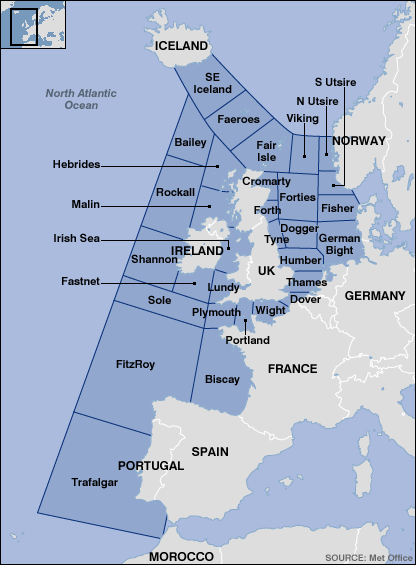
Sea area boundaries used in the Shipping Forecast — Wight is the small area covering the Solent, Southampton Water and the Isle of Wight, between Portland and Dover.
Source: Met Office, on behalf of the Maritime and Coastguard Agency • See also: Shipping Forecast (Audio) • Inshore Waters Forecast • UK Wave Height